Showing posts with label Google Earth. Show all posts

19 March 2018

There in a Flash!

I have been experimenting with different ways to view bus routes using Google Earth and have finally produced a video which I think does give a good impression of a route, in this case, my local bus - the Plymouth Citybus 50, Yellow Flash.
We start at Derriford and go on an extremely fast trip around the city (172mph!) arriving back at Derriford 6 minutes later…
I think I might just slow it down a bit next time but otherwise I am happy with it so far. If it does not work directly on the blog you might get a better view of the video here on You Tube where you can get a better larger view.

The route itself falls from 450 feet above sea level just above Derriford Hospital to a mere 10 feet above sea level on The Embankment, with a few fairly steep climbs along the way as can be seen in this route profile which is another handy tool on GE.
profile 50
All in all I think the advances that Google have made in the 3D rendering of their Earth maps has made these 3d views a lot better than they used to be, and more importantly a lot easier / faster to to produce than ever before. Hopefully more of these will follow in due course

06 November 2007

Changes Part 6

Plymouth International Bus Park

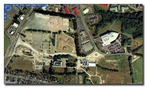
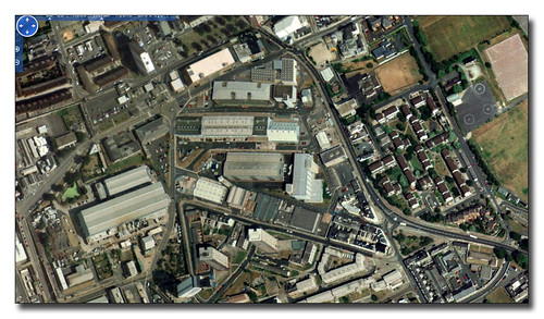
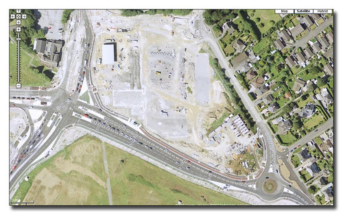
Just down the road from Derriford Roundabout we get the entrance into Plymouth International Business Park. This used to be the site of the old Army Barracks which is now all cleared slowly being filled with new office units. In the old image above from Microsoft you can see the site has been cleared. The main road network has also yet to be built. The main entrance from Crownhill end is under construction across the middle of the photo. Seaton Barracks Swimming pool is at the end of what is still a large culdesac. The modern Western Morning News building stands proud towards the top right.

 Plymouth International Bus Park

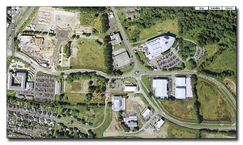
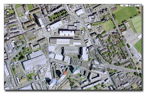
In Google Maps much newer image we see that a lot has changed. The main road network has been constructed and several new office blocks have been built in the estate visible in the middle of the image. One of these is Bircham House used by Plymouth Hospitals NHS where I worked for a couple of years. The main HQ of ROK is also on this site. The new radiology Accademy sits just below the still present Seaton Barracks Swimming pool. The large square building on the extreme left is the Land Registry complex which opened a couple of years ago. Above this is the construction site that will soon end up as the new hotel that stands proud on this site.

Back on the right hand side below the Western Morning News are another set of units including the large private Orthopaedic Centre.

Changes since these images have seen the completion of the hotel and a few more office blocks . The swimming pool has now been demolished.

01 November 2007

Changes part 5

roundabout ms

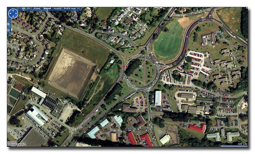
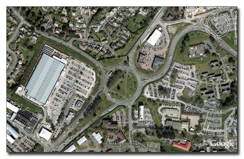
The Microsoft image of Derriford Roundabout is quite old so gives us a good opportunity to see how much has altered over the past few years in what is now an extremely busy part of Plymouth. You can see how different the Google Maps view below is...

roundabout ms

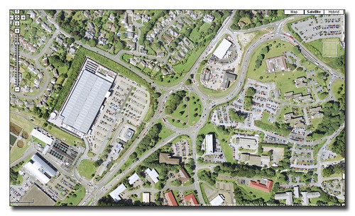
The biggest change is the new B & Q store development to the left of the roundabout. The large DIY store and the smaller KFC produce a lot of traffic as the large car park is well used. The other noticeable change is just to the North of the roundabout where the open field now contains the Jack Rabbit Pub and hotel block, and a large Mercedes Dealership.

Derriford Roundabout

The latest Google Earth image and at first its hard to see if anything has changed that much. The two changes I have noticed are the new white block by the road entrance to the B&Q site bottom left which is a brand new M&S food store which is proving very popular and resulting in very heavy traffic in this area at the moment. The other change is at the extreme top right of the image where you can see more building work on a few buildings backing onto the airport site. It may seem that there is little scope for much more development in this area but more development is indeed planned! The Norwich Union building by the roundabout is being extended and there are plans for the hospital land to the top right of the roundabout which could eventually lead to a multistorey car park or more building on this part of the site. The traffic certainly isnt going to get any lighter anytime soon!

29 October 2007

Changes Part 4

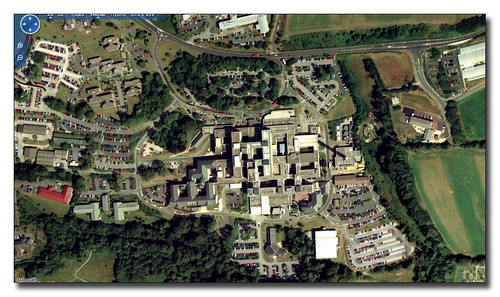
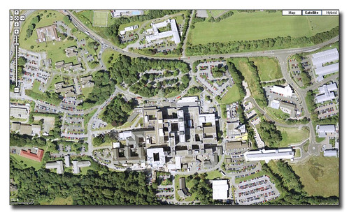
Part 4 of this series and we are looking down at Derriford Hospital.

Derriford

Microsoft have the oldest image which serves as our base for development over the past few years. We start with google Maps:

Derriford

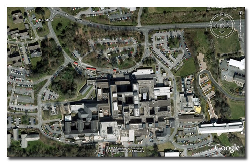
Perhaps the biggest area of change is on the right hand side of the Derriford complex with a large new building straddling the valley between the Hospital and the Tamar Science Park. This is the new University Medical School. The other new part which is slightly harder to find is the new Cardiac complex which appears as a bright square shaped block one inch from the bottom in the middle of the image above.

Derriford

This new block is easier to see in the latest image which actually does not show that much change since the one above.

28 October 2007

Changes Part 3

The third in out series of changes of the Plymothian Landscape as seen from above covers the South Yard redevelopment of Devonport where a large section of former MOD property is returned to civilian use.Regeneration

Here in the Microsoft image we see the South Yard section as it was before any of the redevelopment has started. All the old dockyard buildings are still present. The old dockyard walls are still in place.

Devonport Regeneration

Google Maps gives us a much clearer image but you can still see little has changed which is a big contract to our next image...

Devonport Regeneration

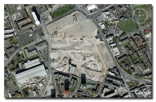
In the very latest image from Google Earth we can get a much better view of the scale of the redevelopment. Almost the whole site has been cleared although much of the outside walls are still in place. This is for construction site security. There is one small new building on the top right hand side of the site which is in use as a development office and viewing area where you can get a better idea of the development. It will be interesting to see the next image update for this area!

From the web site:

Plans for the site include the provision of over 450 high-quality homes, a community healthcare centre, new supermarket and shops, offices and managed workspace.  The historic Market Hall building will be retained and key areas have been allocated as public open space.

Plymouth data has a page for this site here which is well worth a look.

27 October 2007

Changes Part 2

The second part of the series looks at The Tamar bridge:

Tamar bridge

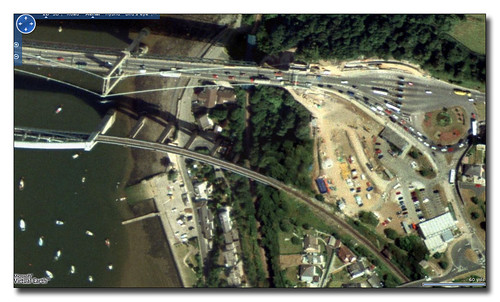
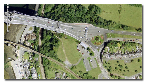
From Microsoft we see that there is a lot of work going on. The main area behind the offices appears to be a large construction site. Its actually in use by contractors working on the bridge widening scheme. By the time we reach our next image from Google Maps we see that the widening work has been completed.

Tamar Bridge New

The image is a lot clearer in Google Maps than Virtual Earth! The construction has cleared and the site returned to a car park and nice clear grass area. You can clearly see the new lines of the bridge road deck - and very elegant it looks too.

Tamar Bridge New

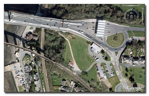
The final most up to date image from Google Earth shows one big change. The new structure over the toll booth area has been completed and shows up very nicely in the new image. You can see that some road resurfacing has taken place too. I have also noticed that the roundabout seems to have lost some of its feature plant beds too!

More Changes to follow tomorrow night...

25 October 2007

Changes Part 1

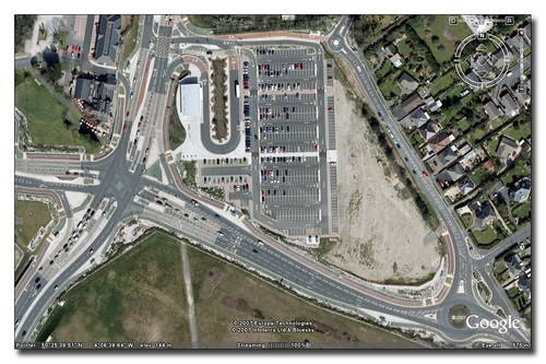
Google Earth has just announced an update of imagery which includes new views of Plymouth which do seem really up to date. As it takes a week or two for the new images to make it to Google Maps there is the opportunity to view a few parts of Plymouth to see how much has changed. We start off with The George Park and Ride.

The George Park and Ride Multimap

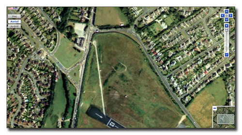
This really is a 'before' image coming from Multimap which is identical to the images used by Microsoft in Visual Earth at the moment. The site is still very much the green field site.

The George Park and Ride Before

Google Maps now and we see construction of the site is well underway. The road junction is pretty much in place but the Park and Ride site itself is still a building site.

The George Park and Ride After

Finally the latest image from Google Earth. All up and running and even a Park and Ride Enviro sitting at the unloading stop! Notice The George Hotel also has a few new buildings on site too.

10 June 2007

Google Maps


I have long been a fan of Google Maps and its bigger sister Google Earth. With the introduction of 'MyMaps' I have now started my owns maps to go with my blogs. Plymothian Bridges now has its own map with each bridge posted on the blog having its own entry on the map.

If you are a Google Earth fan you can also open these maps there. Just click the KML link on the map and either save file - and open from within Google Earth, or just open from within maps and it will open up Earth with my data as a new layer. If you are anything like me this you will then end up playing with Earth all evening and suddenly realise how late it is!


01 January 2007

Laira Depot Before and after


I have been spending some time looking at mapping and satellite imagery of Plymouth available on line to see how I can make best use of it for Plymothian Transit.
Today I had a quick look at MSN Live and came across this image for Plymouth, Laira which still shows the old bus depot!
While it is great to get a nice before and after shot of the same location it is a bit of a poor showing from MSN!


Laira Depot Google

30 November 2006

Google Maps and Google Earth


I mentioned a few days ago that Google have updated the views of Plymouth on Google Earth with much clearer hi res images than before. Well they have now migrated through to Google maps too!

So today we have a few images taken from Google Earth which show the two main bus garages in Plymouth...
Milehouse, home of Plymouth Citybus is seen above.

Below we see First Devon and Cornwalls The Ride.

The Ride 1
This next image is from just up the road and is the spare parking area that FDC are / were using. It does seem odd that the few buses there are spread out across the site! note the yellow and purple buses to the left of the parking area. I am guessing that these were ex Thamesway Mercedes Varios

The Ride 2

26 November 2006

Two quick notes

Two little things I have noticed this week:

If you, like me, are a fan of Google Earth then you might like to take another look at Plymouth. This last week or so has seen an update and Plymouth is now in a much higher resolution and, more importantly, a lot more of the city is now available to view. Previously you couldnt view much of the North of the City (Derriford Hospital was out for example) but now you can get a much better idea of how Plymouth looks from the air. It is expected that Google Maps will catch up shortly - they still use the old images at the moment.

The second thing I noticed this week, of slightly less importance in the world of computing, but more important to me at least, is that this blog has now passed 10,000 visits (counting from 1st January 2006). November is going to be the busiest month yet standing at 1500 visits so far. When I look back and see than January 2006 saw 250 visits I realise how far things have come. The most satisfying thing for me is that I can see that most of the visits these days are people who come straight to the blog - ie are actually wanting to visit rather than finding it by accident.

As I said in my first post 31st March 2005:
Well, here it is, My first attempt at a blog. At this point I dont really have a clue what is going to appear here or how it is going to end up looking, but I will concentrate on what is happening with the transportation in and around Plymouth, England. I will try and post something every day if I can. This will either be something that has caught my attention that day or maybe just something of interest from my files.So sit back and relax, and wait - something interesting might just appear at some stage - you never know!
It seems I have managed to post at least a few interesting somethings along the way!

15 April 2006

Millbay Station

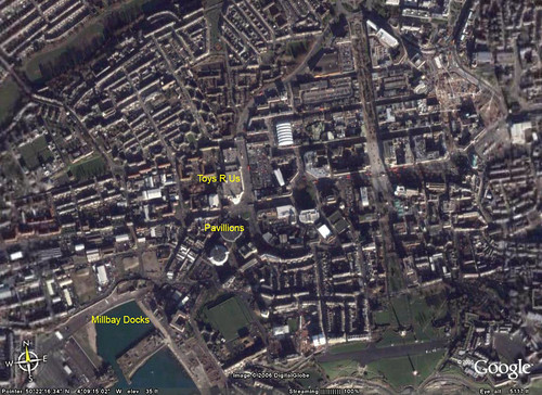
A couple of nighst ago there was a 'ram-raid' on the Plymouth Pavillions in which a large amount of cash was stolen from a cash machine. This in itself has nothing really to do with Transport in Plymouth but the site of the Plymouth Pavillions has an awful lot of interest.
This picture from Google Earth shows the scene as it is now.
(Click on the pictures to get to the Flikr page where you can view them at a larger size for better viewing!)

newmap
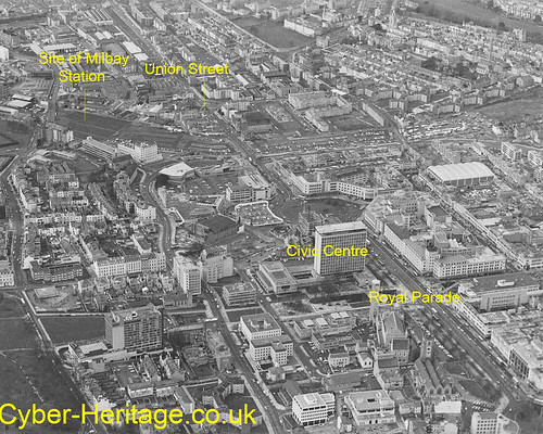
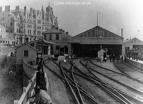
The Plymouth Pavillions is at the entrance to Millbay Docks. And this is the key to the site as it was on this very spot that Millbay Station was sat. This was a main line station which was built to the serve the Docks.
Plymouth Data has an excellent history of the Railway Station here.

City-centre-path-of-railway

This picture taken from the excellent Cyber Heritage collection was taken in the early 1980's and shows the area before any of the new building work had started. You can clearly see the line of the old railway along the top half of the picture and the large area now occupied by the Pavilions in the top left.
Millbay-Station-Hotel
The picture above also from Cyber Heritage is an old one of the Station itself. The hotel in the background is still there.
I hope to do a bit of exploring around here at some stage to see what if anything is left!

Just one other thing to say for now - the whole future of this site and the Pavillions is uncertain as there are grand plans for this area of Plymouth - and the Pavillions is not included in them, so they may not last that much longer. Although dont get too excited - this is Plymouth after all.

02 April 2006

Plymouthian Transit Walkabout: Cattedown

It was a lovely day today so I finally got out and about on a Plymouthian Transit Walkabout.
The area covered can be seen in the © Google Earth image below which has been indexed with the location of each photograph.
00-Index
The highlight for me was to catch this working train on the Cattedown Oil Terminal site.

26-Train-working

The full set of photos can be seen on my Flickr collection by clicking here. I hope to be adding a few more photos soon to show how things have changed over the years. I will slowly be adding a few bits to the captions as I find out more information on the area.

25 March 2006

Teats Hill


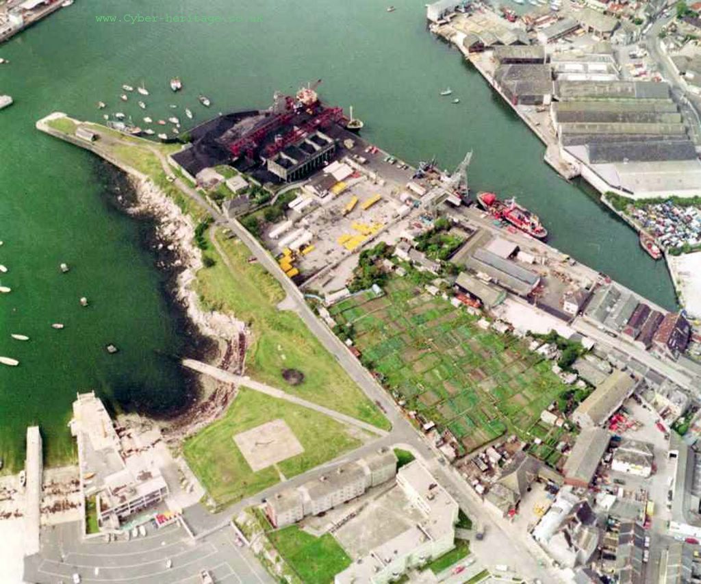
Following on from the news that we will soon be seeing Ducks use the slip way at Teats Hill I thought it would be good to have a closer look at the area. The Teats Hill Slipway can be clearly seen in this lovely photo from about 1980 which has come from the excellent CyberHeritage site. (Click on the photos for a bigger view)
If you look at the image below from Google Earth you will see how much the area has changed.
The main change being the new Plymouth Marine Aquarium building which has sprung up. You may also notice the changes behind the aquarium where the dock side has been filled in. The area where the red ship sits above is now dry land and a very nice pub/ restuarant.


There is a whole lot of things I could point out in this area where there is so much history - and indeed Transport History I could fill pages and pages. One day I will have more information on a proper Plymothian Transit web site which will link the now with the then.


didbygraham