Showing posts with label Google Map. Show all posts

20 January 2012

Google Maps now take the train

As you have probably guessed by now, I am quite a fan of Google Maps. Well the service has now got even more useful in that you can now get basic train information when you ask for directions as well as the standard car journey directions and bus travel.

So I want to get to Looe so I use Google Maps and it shows me the route to take by car

DBG- 001

But now If I select the public transport icon (just above the word Plymouth top left) I can see three options to travel listed below. You can change the date and time if you are planning ahead which is even more useful for planning a train journey. The lines on the map show the connections between scheduled stops so a non stop run would be a single line between Plymouth and Liskeard, whilst this one below stops twice along the journey. A nice easy way to highlight what should be quicker options.
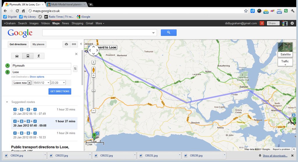
DBG- 002

Scrolling down you see the full journey details with the train journey highlighted (ie Exeter St Davids to Par) and the journey time.
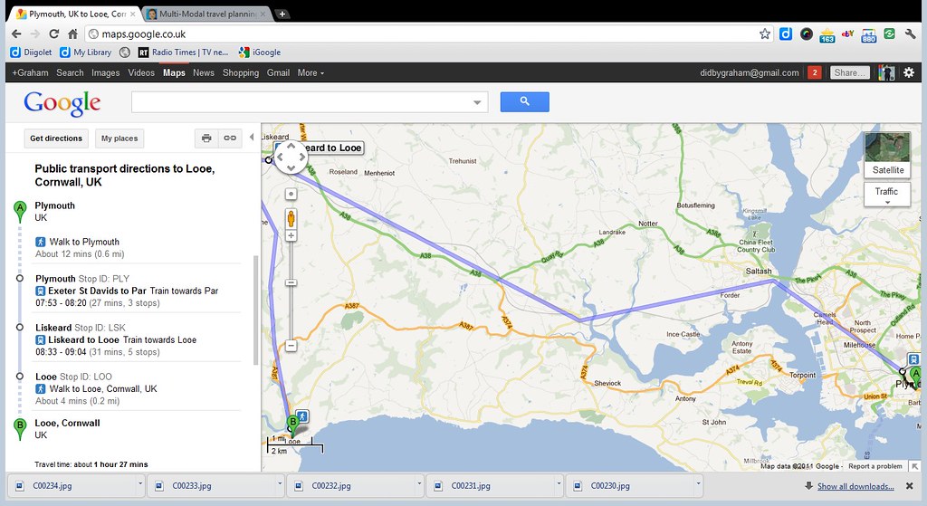
 

DBG- 003

Below this you then get the links to the web site of the train operator for the journey you have picked and also a link for ticket prices. The ticket prices link actually takes you the The Trainline who have supplied Google with the timetables etc to make all of this work so seems fair enough. Sadly when you get the The Trainline you have to enter the journey details again to get the ticket prices etc which is a shame but isnt too difficult. You can of course go through the First Great Western site and get the tickets through them and avoid the credit card surcharge.
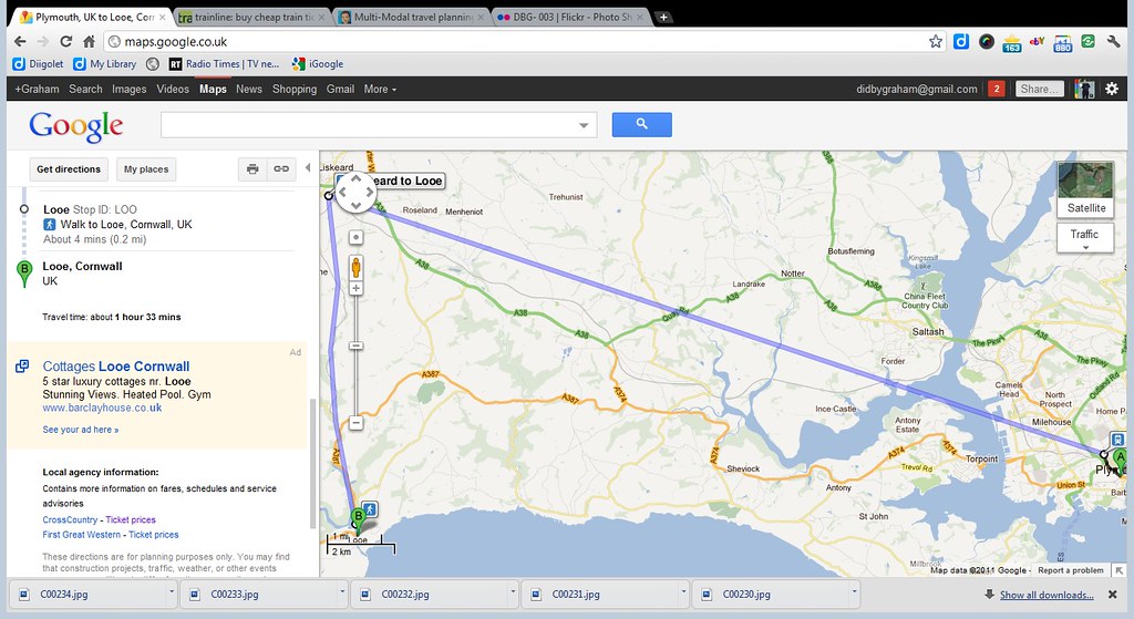
DBG- 004

The National Rail information joins local transit data, to offer true national multi-modal travel planning to users of Google Maps on the web, and more importantly mobile via Google Maps for Mobile. This is a great example of the benefits of opening up public data sets, the national rail timetable data is been provided via the people at thetrainline.com who have great expertise in dealing with the complexities of the unique railway system in Britain. [Source: EdParsons]


Recommended Links

  • The Portsdown and Horndean Light Railway (please don't call it a tram; it was operated under a "Light Railway Order" by the Provincial company) operated from 1903 to 1935. Public Transport Experience
  • I’ve always wondered why our school days were so short when compared to our continental neighbours. From what I have seen, English pupils at a particular age always seem to be one educational step behind those from, say, France. Omnibuses
  • took my first trip to Bristol in the greatest month of change for the bus industry, October 1986. I must have liked what I have seen because I returned later the same month, just before Deregulation Day on the 26th. Transport Illustrated
  • The Portsdown and Horndean Light Railway, which ran from 1903 to 1935, operated from Cosham then up the spectacular Portsdown Hill, with its stunning views back over Portsmouth Harbour, ... Public Transport Experience
  • Over 40 comments on the post about Damory down registrations on the 347/87 & associated services, plus a couple that have spilled over elsewhere. Dorset Bus Blog
  • It hit the news before Christmas but has subsequently re-emerged. It’s the demand by Unite (a union) that platform staff be given a £500 bonus for working the three weeks of the olympics and paralymics Omnibuses
  • And then there was one... K803 ORL has today most likely transported her passengers (for part of the journey at least) for the final time today PTOTPA

12 March 2010

Bus Spotting without leaving the house

Google Street View now live for Plymouth


Yesterday was a day that many of us have been waiting for, as it was the day that Street View was finally turned on for Plymouth, along with much of the rest of the UK. Although Google have tried to blur registration numbers and peoples faces you can do a fair bit of bus spotting etc on the streets of Plymouth as can be seen below.
View Larger Map

View Larger Map

View Larger Map
Further Reading
Transport of Delight: Gibraltar, detailed post
Uncle Terry: 27 Man of Granite, 28 - who knows what lurks..., 29 - snow good...
TGP: Woody
Leon Daniels: 888


First on Twitter / Facebook
09 Mar
09:18 It's the Gold Star Award Ceremony tonight. The 12 monthly winners, plus First's winner Steve Callaghan and the Stephanie Hammacott youth award winners will be presented with their trophies by Heart South Hams' Martin Mills. The Gold Star Award winner of the year will also be announced. A huge congratulations to all winners - we will report back on the event tomorrow (you can also read about the awards in The Herald)
13:04 PLYMSTOCK: Good news Holmwood Avenue is now open so ugobus service 6 is back to normal, running up to every 15 minutes
13:47 DEVON & CORNWALL: For details of our Easter Bank Holiday weekend services plus Travel Shop & Customer Service opening hours please click here
10 MAR
Congratulations to all of the Plymouth Gold Star Winners, including Gold Star Winner of the year; Annie Wakeham and Stephanie Hammacott Award Winners Dan and Amy Cormack . For the full story and to watch highlights of last nights awards ceremony click here
16:28 PLYMOUTH: Delays around the Derriford & Crownhill area due to roadworks and rush hour traffic. Affecting services 7, 15, 17 and 83/84/86. Thanks for your patience.
Citybus on Twitter / Facebook
09 Mar
11:45 After several weeks Holmwood Avenue in Plymstock has reopened allowing our popular 5 and 5A services to revert to their normal route. Hopefully this will save you a long walk! We are pleased to be back for you and look forward to your continued support.
13:45 Taunton Avenue is blocked by an accident in which a van has overturned. We are advised that the road may be reopened by 4pm Sorry for any inconvenience this will cause. Buses will use Budshead Road and turn at the Green
14:56 Taunton Avenue has reopened and our 44 and 44A services are returning to their normal routes. Hope you weren't too inconvenienced.
10 Mar
16:08 We apologise but yet again the road works at Crownhill and the ongoing saga of Derriford Hospital traffic delays are causing major disruption to our services. These hold ups are entirely beyond our control and we share your frustration that we are unable to offer a reliable service to our customers
17:57 There is no improvement at Derriford with some buses not moving for 20 minutes. Traffic management is non existent. How you are supposed to get home and how we are supposed to run a service is beyond us.
(You can also see a lot of unhappy comments especially from service 50 passengers. As I blogged yesterday I was caught up in this too, I dont blame Citybus though. Thursday evening traffic was moving freely, and there did seem to be staff on hand ready to control traffic out of Derriford if needed)

PlymTransit on Twitter

17 June 2008

Odds and Ends

Running a few major computer updates etc tonight so not much time to do much else.

Plymouth Citybus are expecting to have received all 11 of their new Enviros by the end of this week. Perhaps more exciting is the imminent arrival of yet another demonstrator in the form of a tri-axle Scania single decker bus - 13M long!

Should be on the road by the end of this week - on the 43 route.

Further afield the new Stagecoach Devon Enviro 400 double Decker buses are into service today with a few second-hand examples coming from Manchester shortly. I must get up there for a ride sometime - before the loss of the X45 makes it more difficult again!

Following on from my post yesterday Doddy has added another route profile for the Citybus 25/ 20 service CLICK HERE

06 November 2007

Changes Part 6

Plymouth International Bus Park

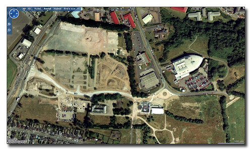
Just down the road from Derriford Roundabout we get the entrance into Plymouth International Business Park. This used to be the site of the old Army Barracks which is now all cleared slowly being filled with new office units. In the old image above from Microsoft you can see the site has been cleared. The main road network has also yet to be built. The main entrance from Crownhill end is under construction across the middle of the photo. Seaton Barracks Swimming pool is at the end of what is still a large culdesac. The modern Western Morning News building stands proud towards the top right.

 Plymouth International Bus Park

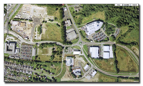
In Google Maps much newer image we see that a lot has changed. The main road network has been constructed and several new office blocks have been built in the estate visible in the middle of the image. One of these is Bircham House used by Plymouth Hospitals NHS where I worked for a couple of years. The main HQ of ROK is also on this site. The new radiology Accademy sits just below the still present Seaton Barracks Swimming pool. The large square building on the extreme left is the Land Registry complex which opened a couple of years ago. Above this is the construction site that will soon end up as the new hotel that stands proud on this site.

Back on the right hand side below the Western Morning News are another set of units including the large private Orthopaedic Centre.

Changes since these images have seen the completion of the hotel and a few more office blocks . The swimming pool has now been demolished.

01 November 2007

Changes part 5

roundabout ms

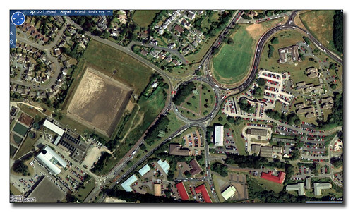
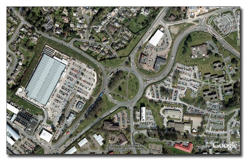
The Microsoft image of Derriford Roundabout is quite old so gives us a good opportunity to see how much has altered over the past few years in what is now an extremely busy part of Plymouth. You can see how different the Google Maps view below is...

roundabout ms

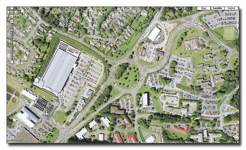
The biggest change is the new B & Q store development to the left of the roundabout. The large DIY store and the smaller KFC produce a lot of traffic as the large car park is well used. The other noticeable change is just to the North of the roundabout where the open field now contains the Jack Rabbit Pub and hotel block, and a large Mercedes Dealership.

Derriford Roundabout

The latest Google Earth image and at first its hard to see if anything has changed that much. The two changes I have noticed are the new white block by the road entrance to the B&Q site bottom left which is a brand new M&S food store which is proving very popular and resulting in very heavy traffic in this area at the moment. The other change is at the extreme top right of the image where you can see more building work on a few buildings backing onto the airport site. It may seem that there is little scope for much more development in this area but more development is indeed planned! The Norwich Union building by the roundabout is being extended and there are plans for the hospital land to the top right of the roundabout which could eventually lead to a multistorey car park or more building on this part of the site. The traffic certainly isnt going to get any lighter anytime soon!

29 October 2007

Changes Part 4

Part 4 of this series and we are looking down at Derriford Hospital.

Derriford

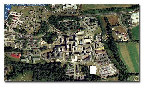
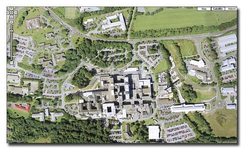
Microsoft have the oldest image which serves as our base for development over the past few years. We start with google Maps:

Derriford

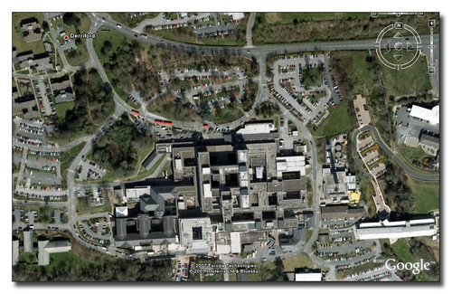
Perhaps the biggest area of change is on the right hand side of the Derriford complex with a large new building straddling the valley between the Hospital and the Tamar Science Park. This is the new University Medical School. The other new part which is slightly harder to find is the new Cardiac complex which appears as a bright square shaped block one inch from the bottom in the middle of the image above.

Derriford

This new block is easier to see in the latest image which actually does not show that much change since the one above.

28 October 2007

Changes Part 3

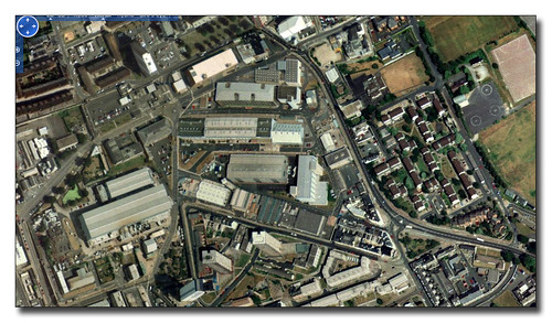
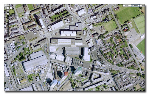
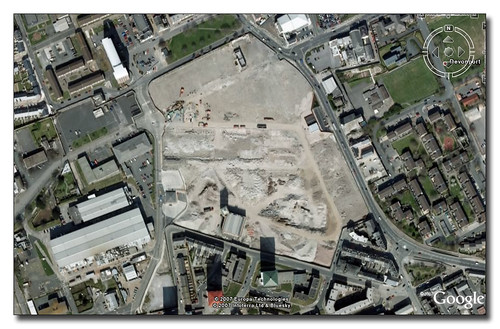
The third in out series of changes of the Plymothian Landscape as seen from above covers the South Yard redevelopment of Devonport where a large section of former MOD property is returned to civilian use.Regeneration

Here in the Microsoft image we see the South Yard section as it was before any of the redevelopment has started. All the old dockyard buildings are still present. The old dockyard walls are still in place.

Devonport Regeneration

Google Maps gives us a much clearer image but you can still see little has changed which is a big contract to our next image...

Devonport Regeneration

In the very latest image from Google Earth we can get a much better view of the scale of the redevelopment. Almost the whole site has been cleared although much of the outside walls are still in place. This is for construction site security. There is one small new building on the top right hand side of the site which is in use as a development office and viewing area where you can get a better idea of the development. It will be interesting to see the next image update for this area!

From the web site:

Plans for the site include the provision of over 450 high-quality homes, a community healthcare centre, new supermarket and shops, offices and managed workspace.  The historic Market Hall building will be retained and key areas have been allocated as public open space.

Plymouth data has a page for this site here which is well worth a look.

27 October 2007

Changes Part 2

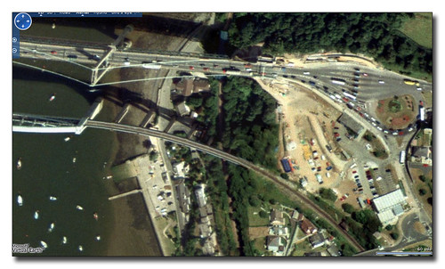
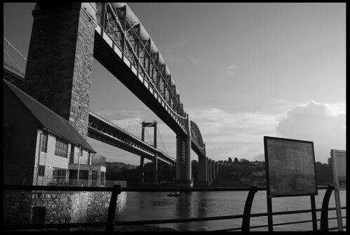
The second part of the series looks at The Tamar bridge:

Tamar bridge

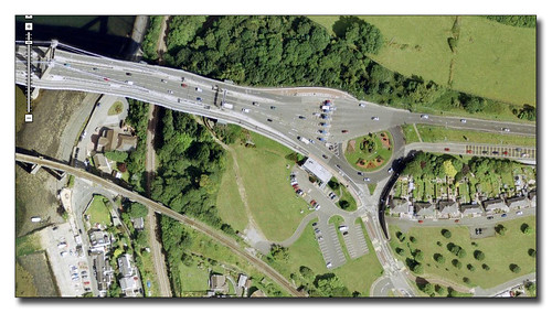
From Microsoft we see that there is a lot of work going on. The main area behind the offices appears to be a large construction site. Its actually in use by contractors working on the bridge widening scheme. By the time we reach our next image from Google Maps we see that the widening work has been completed.

Tamar Bridge New

The image is a lot clearer in Google Maps than Virtual Earth! The construction has cleared and the site returned to a car park and nice clear grass area. You can clearly see the new lines of the bridge road deck - and very elegant it looks too.

Tamar Bridge New

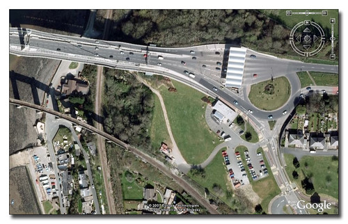
The final most up to date image from Google Earth shows one big change. The new structure over the toll booth area has been completed and shows up very nicely in the new image. You can see that some road resurfacing has taken place too. I have also noticed that the roundabout seems to have lost some of its feature plant beds too!

More Changes to follow tomorrow night...

25 October 2007

Changes Part 1

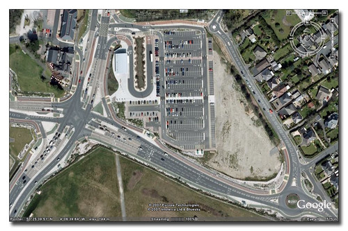
Google Earth has just announced an update of imagery which includes new views of Plymouth which do seem really up to date. As it takes a week or two for the new images to make it to Google Maps there is the opportunity to view a few parts of Plymouth to see how much has changed. We start off with The George Park and Ride.

The George Park and Ride Multimap

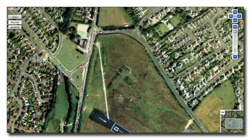
This really is a 'before' image coming from Multimap which is identical to the images used by Microsoft in Visual Earth at the moment. The site is still very much the green field site.

The George Park and Ride Before

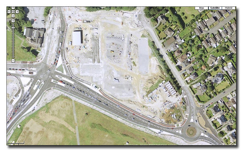
Google Maps now and we see construction of the site is well underway. The road junction is pretty much in place but the Park and Ride site itself is still a building site.

The George Park and Ride After

Finally the latest image from Google Earth. All up and running and even a Park and Ride Enviro sitting at the unloading stop! Notice The George Hotel also has a few new buildings on site too.

10 June 2007

Google Maps


I have long been a fan of Google Maps and its bigger sister Google Earth. With the introduction of 'MyMaps' I have now started my owns maps to go with my blogs. Plymothian Bridges now has its own map with each bridge posted on the blog having its own entry on the map.

If you are a Google Earth fan you can also open these maps there. Just click the KML link on the map and either save file - and open from within Google Earth, or just open from within maps and it will open up Earth with my data as a new layer. If you are anything like me this you will then end up playing with Earth all evening and suddenly realise how late it is!


08 June 2007

Plymothian Bridges


© Young Sheezy (Flickr Blog this)

I have chosen this excellent photo (via Flickr blog this) to illustrate the fact that I have re-launched Plymothian Bridges blog. I set this up ages ago on another blog platform, which although in many ways superior to Blogger, it has proven to be difficult to keep up to date and it fell behind. I am now reposting the original entries over onto the new site and will then get back to regular updates. Feel free to have a look sometime!

Plymothian Bridges

Plymothian Bridges Map